How the Weather Is Predicted
When meteorologists predict the weather they use several different types of equipment. They use Doppler radar, satellite, radiosondes, ASOS II (automated surface-observing systems), supercomputers, and AWIPS (Advanced Weather Information Processing System).
- Doppler radar detects all types of precipitation, the rotation, location, and velocity of thunderstorm clouds, airborne tornado debris, wind strength, and direction. Weather satellites monitor Earth from space every 30 seconds, sending pictures to meteorologists.
- Radiosondes are meteorologists primary source of upper-air data. They use weather balloons to carry the radiosondes, which float to the upper stratosphere to collect and send back data every second about air pressure, temperature, relative humidity, wind speed, and wind direction.
- ASOS II is constantly monitoring the surface weather. About 12 times an hour, the station sends information about the sky conditions, the surface visibility, the precipitation, the temperature, and the wind. All this data is then given to the supercomputer.
- NOAA’s Weather and Climate Operational Supercomputer System is one of the most powerful supercomputers in the USA. This supercomputer takes the collective data from the Doppler radar, radiosondes, weather satellites, and other instruments, and calculates it into forecast models. The computer calculates the data of the atmospheric conditions that transpired in the past and the current weather patterns.
- AWIPS is a computer processing system that combines data from all the previous tools into a graphical interface. This system uses NOAA supercomputers to process data from Doppler radar, radiosondes, weather satellites, ASOS II, and other sources using models and forecast guidance products. AWIPS delivers precise forecasts sooner so that forecasters can use the analyzed data to prepare and issue forecasts, watches, and warnings. After meteorologists prepare the forecasts, AWIPS generates weather graphics and hazardous weather watches & warnings. All this helps meteorologists to create accurate forecasts faster than ever before. With this information, meteorologists then make educated guesses about the future weather.
Understanding the Weather and How You Can Use It to Your Advantage
In order to predict the weather, you’re going to need some information about your location: air pressure, temperature, relative humidity, wind speed, wind direction, and clouds.
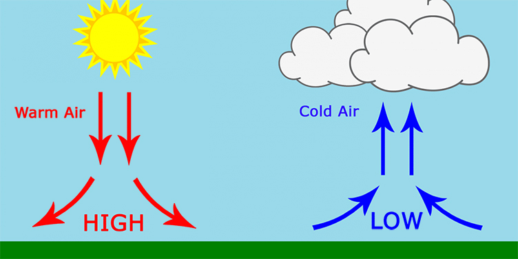
You want to be observant of the wind and air around you. Air naturally flows from one pressure zone to the next. Zones of low and high pressure cover the world. Low pressure is when warm air ascends from the Earth’s surface in an anticlockwise direction. As warm air rises and cools, water vapor condenses to form clouds and perhaps precipitation. This normally brings clouds and stormy weather with strong winds. Winds tend to blow towards the low-pressure zone. These zones are also responsible for storms. High-pressure zones have winds that tend to be light and blow in a clockwise direction. Cold air is pushed down, which reduces the formation of cloud and leads to light winds and settled weather conditions. Winds blow away from high pressure.
 Remember That Rising Air = Moistening And Sinking Air = Drying
How can you tell when you are in a high or low-pressure area? Since weather blows in from the west, westerly winds indicate good weather. It’s been said that bad weather comes from the east. Easterly winds suggest that the bad weather is coming toward you. You can see the different pressures in smoke: in high pressure, the smoke will go directly up into the air; if the pressure is low, then the smoke will spiral back down around the fire. If this happens, then, most likely, bad weather is on its way. Look out for calm conditions. During a low-pressure zone, the area’s normal winds are disturbed. Water and trees will calm. Insects come out to either return home before the storm or to inspect. Insects and reptiles are sensitive to the pressure changes. Also, when there is a low-pressure zone, birds will fly low to the ground to avoid the strong winds higher up, and the frogs will croak in unison.
The temperature gets cooler as the storm rolls closer. As the front continues to move, temperatures will continue to gradually decrease until they bottom out. It’s been recorded that temperatures can drop anywhere between 1 and 10 degrees! A warm front = warm weather, and a cold front = cool weather.
Humidity will also help you predict the weather. High humidity often precedes a storm, so be on the watch for signs of high humidity. Frizzy hair, curling leaves, and sticky doors and/or windows from swollen wood. These signs can tell you that a storm is on the way.
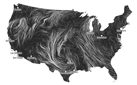
 Here Is Where The Wind Directions Are On a USA Map
 USA Map On Winter Wind Patterns
In order to predict the weather fully, you need to be aware of wind speed and the wind direction. Your terrain will have an effect on your weather. Warm, moist air is forced to rise by hills, mountains, or areas where warm/cold or wet/dry air bump together. This is where thunderstorms can form. The surface direction of wind varies depending on your location (northern/southern hemisphere, and coastal/plains/mountains), and what weather patterns normally affect your area. Winds from the northwest normally bring cooler and drier weather to the eastern United States. While southwesterly winds bring warmer and drier weather. During the winter months, southeasterly winds produce rainy, but warmer, weather along the east coast. Using these basic rules, it is possible to predict future weather if the location and time of year are considered.
Cloud Watching
When predicting the weather and have no equipment, nothing is more reliable than watching the clouds around you. The clouds are telling you what is happening around you. Cumulus clouds are the most recognizable clouds. Air rises vertically into the atmosphere and condenses into puffy, cotton-like clouds that we all know. Typically, cumulus clouds are associated with pleasant weather. Cumulonimbus clouds occur when the updrafts become stronger, the cumulus clouds may grow taller into what we call cumulonimbus clouds. These are the inspiring, ominous clouds that can be an indication of developing thunderstorms, including lightning, hail, heavy rain, and even tornadoes. Stratus clouds look like a layer of gray blanketing the sky. They are generally associated with wet conditions. They typically form when warm air is lifted over cold air transforming the sky into a gray and dreary scene. Stratus clouds can last for days and bring cool temperatures, persistent rain, drizzle, or even snow. The last clouds I’d like to talk about are Cirrus clouds. Cirrus clouds are white wispy clouds that stretch across the sky. They indicate that fair weather is in the immediate future.
All in All
This is a fun experience for anyone to try. I not only enjoy meteorology, but I love sharing it with others. Mother Nature is awe-inspiring. If you have any questions or would like us to do more blogs about weather visit our Facebook page!
Please remember, the weather forecast is an educated guess—no one can control the weather.
